


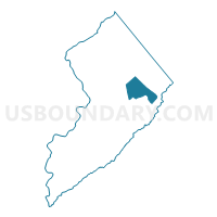
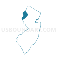
Independence township voting district 1, Warren County, New Jersey
About
Outline

Summary
| Unique Area Identifier | 622835 |
| Name | Independence township voting district 1 |
| County | Warren County |
| State | New Jersey |
| Area (square miles) | 12.36 |
| Land Area (square miles) | 12.24 |
| Water Area (square miles) | 0.12 |
| % of Land Area | 99.03 |
| % of Water Area | 0.97 |
| Latitude of the Internal Point | 40.89248120 |
| Longtitude of the Internal Point | -74.88137880 |
Maps

Graphs
Select a template below for downloading or customizing gragh for Independence township voting district 1, Warren County, New Jersey


Neighbors
Neighoring Voting District (by Name) Neighboring Voting District on the Map
- Allamuchy township voting district 2, Warren County, NJ
- Allamuchy township voting district 4, Warren County, NJ
- Frelinghuysen township voting district 2, Warren County, NJ
- Hackettstown town voting district 3, Warren County, NJ
- Hackettstown town voting district 4, Warren County, NJ
- Hope township voting district 2, Warren County, NJ
- Independence township voting district 2, Warren County, NJ
- Independence township voting district 3, Warren County, NJ
- Independence township voting district 4, Warren County, NJ
- Liberty township voting district 1, Warren County, NJ
- Liberty township voting district 2, Warren County, NJ
Top 10 Neighboring County Subdivision (by Population) Neighboring County Subdivision on the Map
- Hackettstown town, Warren County, NJ (9,724)
- Independence township, Warren County, NJ (5,662)
- Allamuchy township, Warren County, NJ (4,323)
- Liberty township, Warren County, NJ (2,942)
- Frelinghuysen township, Warren County, NJ (2,230)
- Hope township, Warren County, NJ (1,952)
Top 10 Neighboring Place (by Population) Neighboring Place on the Map
- Hackettstown town, NJ (9,724)
- Panther Valley CDP, NJ (3,327)
- Vienna CDP, NJ (981)
- Great Meadows CDP, NJ (303)
Top 10 Neighboring Elementary School District (by Population) Neighboring Elementary School District on the Map
- Allamuchy Township School District, NJ (4,323)
- Frelinghuysen Township School District, NJ (2,230)
- Hope Township School District, NJ (1,952)
Top 10 Neighboring Secondary School District (by Population) Neighboring Secondary School District on the Map
Top 10 Neighboring Unified School District (by Population) Neighboring Unified School District on the Map
Top 10 Neighboring State Legislative District Lower Chamber (by Population) Neighboring State Legislative District Lower Chamber on the Map
Top 10 Neighboring State Legislative District Upper Chamber (by Population) Neighboring State Legislative District Upper Chamber on the Map
Top 10 Neighboring 111th Congressional District (by Population) Neighboring 111th Congressional District on the Map
Top 10 Neighboring Census Tract (by Population) Neighboring Census Tract on the Map
- Census Tract 312, Warren County, NJ (7,949)
- Census Tract 313.01, Warren County, NJ (5,662)
- Census Tract 314.02, Warren County, NJ (5,134)
- Census Tract 314.01, Warren County, NJ (4,590)
- Census Tract 313.02, Warren County, NJ (4,323)
- Census Tract 311.02, Warren County, NJ (3,917)